Today, accurate weather observation is of critical importance as climate change is threatening traditional agriculture. Farmers need accurate information to adapt and continue their operations. Here comes the agriculture UAV as a solution.
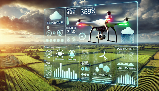
This unmanned aerial vehicle is outfitted with advanced sensors for the calibration of its analytical capabilities that can take in real-time meteorological data. This technology helps farmers in meteorological forecasting, agricultural practices, and management of crops.
The Importance of Weather Monitoring in Agriculture
Weather is a dynamic phenomenon that generates possible changes in all agricultural practices. Weather has had an impact on crop growth, production, and pest management. As a result, expected climate patterns have become increasingly unpredictable in recent times. Current forecasting models are unable to meet the modern-day requirements of farming. There is a growing need for local, real-time weather data for proper planning of farm activities. Agricultural UAVs play a crucial role in achieving this with a high degree of accuracy.
How Agriculture UAV Monitors Weather Conditions
Agriculture UAV incorporates sensors that record all environmental conditions, such as temperature, humidity, wind speed, and, at times, even rainfall conditions.
Let’s have a look at how these agricultural UAVs are used in weather monitoring:
- Data Collection from Above: Agriculture UAVs fly over farms and collect data from approximately 1 meter above the ground. This provides a multidimensional view of weather across the farm. Microclimates—small areas with climate conditions different from the rest of the field—-can be easily identified and monitored by farmers.
- Advanced Sensors and Imaging: Agriculture UAVs can collect the data using onboard high-resolution cameras. These sensors record temperature changes, soil moisture content, and plant health indices, helping to determine if plants are affected by drought or adverse weather.
- Real-Time Data Transmissions: Agriculture UAVs transmit the data collected in real-time. This information is precious as it provides pre-alerts before weather changes occur or any extreme events arise. This is particularly useful in preparing against bad extreme weather—a situation such as heavy rains or frost.
The Technologies Behind Agriculture UAV
Agriculture UAV utilizes a series of advanced technologies to monitor weather and environmental conditions more effectively.
- Sensor Technology: Sensor technology is designed and adapted to the following measurements: temperature, barometric pressure, humidity, and wind speed. These measurements form the basis for accurate weather predictions.
- Thermal and Multispectral Imagery: Thermal cameras can detect temperature differences, while other cameras provide growth data on plants, nutrients in soils, and their dryness status.
- Artificial Intelligence and Machine Learning: By combining historical weather data with real-time updates, AI and machine learning improve forecasting accuracy, enabling farmers to make well-informed decisions.
- GPS and Geographic Information System (GIS) Mapping: Besides ensuring flight routes for accurate data collection, GIS technology spatially visualizes weather information to allow localized climatic assessment and analysis.
- Remote Sensing and IoT Connection: The UAVs of agricultural development cause remote sensing measurement regarding the weather conditions of the specific area and connect the entire phenomenon with IoT for comprehensive data evaluation.
- Data-cloud Service and Analysis: Agriculture UAV synchronize collection of information with cloud servers, making data accessible for thorough analysis using the web or mobile applications.
- Advanced Flight Control Systems: Software-based autonomous flight control with different software systems enables agricultural UAVs to perform the most important range of tasks, from seeding to synthesizing data for weather analysis.
Predicting Weather Patterns with Agriculture UAV
Using the data gathered from agriculture UAV, farmers can better predict weather patterns specific to their region. Here’s how this helps:
- Forecasting Rainfall and Irrigation Needs: By analyzing humidity levels and cloud cover, agricultural UAVs can make estimates of rainfall, thereby enabling farmers to optimize irrigation schedules and save water during dry spells.
- Frost Detection and Prevention: For crops prone to frost, agricultural UAV can help check on farmers on lowering temperatures that could harm them. This provides farmers some warning time to apply measures such as covering up crops with crop covers or frost protection.
- Wind Monitoring for Pesticide Application: With the help of real-time wind data provided by agricultural UAV, farmers can decide on the best time to apply pesticides or fertilizers, reducing wastage and minimizing environmental impact.
Key Sensors in Agriculture UAV for Weather Monitoring
The below table summarizes the key sensors used in Agriculture UAV for weather monitoring, highlighting their functions and technologies, such as temperature, humidity, rain detection, and pressure sensors, all integrated with Arduino for real-time data collection and analysis.
|
Component |
Function |
Technology Used |
|
Temperature & Humidity Sensor |
Measures temperature and humidity; uses a capacitive humidity sensing element and thermistor. |
DHT11 Sensor (Capacitive & Thermistor) |
|
Rain Drop Sensor |
Detects rain by measuring resistance change due to water exposure. |
LM393 Op-Amp (Rain Board Module) |
|
Pressure Sensor |
Measures atmospheric pressure, adjusts for temperature-induced air density changes. |
BMP180 Piezoresistive Sensor |
|
Data Processing & Analysis |
Collects and processes data, sends it to a data logger. |
Arduino (C Programming for Data Analysis) |
FAQs
In what way does agricultural UAV improve weather monitoring for a farmer?
Agricultural UAV collects real-time weather data on various environmental conditions, including temperature, humidity, wind speed, and precipitation. These microclimate insights from the field provide farmers with specific details that help predict weather changes, which may affect crop management.
Is agriculture UAV complicated for farmers who have no technical expertise?
Not really. Many drones have basic interfaces, and some even operate with fully automated flight systems, requiring little technical knowledge from farmers. Additionally, companies often provide training and support to help farmers use drone technology effectively. This aids in better weather monitoring and improved agricultural management.
Conclusion
As farmers face adverse weather conditions due to climate change, precision weather monitoring becomes critical for achieving better crop yields. To address these challenges, agricultural UAVs equipped with advanced sensors and analytical tools play a crucial role. They are capable of capturing finely detailed real-time weather data. This technology enables farmers to make accurate forecasts about weather changes, adapt farming practices, and better manage crop production.